
In this digital era global internet expands billions of connected devices, determining the exact location of a user or a server is very important for law-enforcement. IP Geolocation is the process to determine the actual geographical position of a server or a user. Commercial geolocation databases are heavily dependent on registry information and crowded-source data, these often lack the precision and dynamism required in critical applications. There Delay Based Geolocation techniques specially Multilateration comes into the picture. Multilateration is a classical technique rooted in geometry and used in various domains as such radar, aviation, SONAR and GPS. In this process we will use the RTT (Round Trip Time) measurements from some known sources to infer the location of an Ip address.
What is Multilateration?
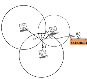
Multilateration is a mathematical technique which helps to determine the position of an object based on it’s measured distance from three or more known reference points. These reference points should have fixed and well-known co-ordinates (latitude and longitude). When the distances from these reference points are known then the position of target point can be inferred.
Mathematical Foundation of Multilateration: –
Let’s see the mathematical underpinnings of multilateration in greater depth. This mathematical section assumes a 2D Euclidean plane where targeted points are located using multilateration estimations from multiple known reference points.
So, for determining the distance from the known reference points to targeted location we have to solve some equations. Assuming that we have n reference points with known location.

The coordinate of the targeted point is

 ………………eq(1)
 ………………eq(2)
 ………………eq(3)
By substituting eq.2 from eq.1
![[(x - x_1)^2 + (y - y_1)^2] - [(x - x_2)^2 + (y - y_2)^2] = d_1^2 - d_2^2](https://portal.aiori.in/wp-content/ql-cache/quicklatex.com-8c72079c698381fcbd70663f5c5c1273_l3.png "Rendered by QuickLaTeX.com")
By expanding we will get:
![[x^2-2xx_1+x_1^2+y^2-2yy_1+y_1^2] - [x^2-2xx_2+x_2^2+y-2yy_2+y_2^2]=d_1^2-d_2^2](https://portal.aiori.in/wp-content/ql-cache/quicklatex.com-3cf39d7f187670f17fdba49c4a56b6c4_l3.png "Rendered by QuickLaTeX.com")
After Simplifying:
![x(x_2-x_1)+y(y_2-y_1)=\frac{1}{2}[{(d}_1^2-d_2^2)+(x_2^2-x_1^2)+(y_2^2-y_1^2)]](https://portal.aiori.in/wp-content/ql-cache/quicklatex.com-8c07f72bcf96a76f5fb92c2819fb79a1_l3.png "Rendered by QuickLaTeX.com")
We can write this equation in this form:

By substituting eq.3 from eq.1
![[(x-x_1)}^2+(y-y_1)^2]-[(x-x_3)^2+(y-y_3)^2]=d_1^2-d_3^2](https://portal.aiori.in/wp-content/ql-cache/quicklatex.com-37ed31d05bdb38489aeac019c01fb0c1_l3.png "Rendered by QuickLaTeX.com")
Similarly, we will get another equation like this:-

We will get a linear system of n−1 equation. We can also write this equation in this form: –

But when n≥4, the system becomes overdetermined — meaning there are more equations than unknowns. In such cases, an exact solution may not exist, but we can find the best approximate solution using the Least Squares Method.


So, after simplifying we can reach to the best approximate solution:-

Implementation of Multilateration in in IP Geolocation
In the AIORI Project, we have deployed a robust infrastructure consisting of nearly 80 geographically distributed anchor nodes across India. The precise geographic coordinates (latitude and longitude) of each anchor node are known, enabling us to utilize them as reference points for various active measurements.
Through our dedicated control panel athttps://services.aiori.in/we have centralized access to these anchors. This portal allows researchers and engineers to remotely perform network diagnostic operations such as ICMP ping, traceroute, and DNS queries from any selected anchor node. These actions are fundamental for delay-based and topology-based measurements, forming the backbone of many geolocation, network performance, and cybersecurity research tasks.
- Using ping, we can gather Round-Trip Time (RTT) data, which serves as a basis for delay-based multilateration techniques—a classical approach in IP geolocation, helping infer the physical location of a remote server or user.
- Using traceroute, we can build an understanding of the network topology and routing paths between source and destination, which is essential for path-based estimation and network diagnostics.
By combining measurements from multiple anchors, we are capable of estimating the location of unknown servers or clients with improved accuracy. This large-scale, distributed testbed not only supports research on internet infrastructure, but also aids in threat intelligence, latency analysis, and policy planning by offering a high degree of visibility into routing behavior and delay dynamics across the Indian subcontinent.
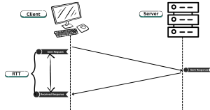
Distance Calculation From Round Trip Time
Round Trip Time (RTT) is the time it takes for a signal to travel from the sender to the receiver and back. RTT is a key parameter in benchmarking and analysis and also it helps in distance estimation in network geolocation and delay-based measurements(ping).The basic idea for distance estimation is that the signal (usually a ping packet or any probe packet like ICMP or UDP) travels through a medium (e.g., fiber optic cable) at a known speed. By measuring the RTT and dividing it by 2 (to get one-way delay), we can estimate the physical distance between the sender and receiver.
The mathematical formula of distance estimation through RTT is :

Where:
RTT: Measured Round Trip Time
v: Propagation speed of signal in the medium
Propagation Speed in Fiber Optic Cable:
In fiber optics, the signal is transmitted as light. However, the speed of light in fiber is not the same as in vacuum. It slows down due to the refractive index (n) of the fiber core material.

c = Speed of light in vacuum ≈ 3.0 x  m/sec
m/sec
n=Refractive index of the optical fiber cable
Problems of Distance Estimation: –
However, this method is riddled with several critical limitations, making accurate IP geolocation quite challenging.
- Indirect Routing Paths
IP packets do not always take the geographically shortest route. Instead, routes are chosen based on network policies, BGP configurations, and congestion. - Asymmetry in Forward and Reverse Paths
RTT assumes the time from the probe to the destination and back is equal, but this is rarely the case in real-world networks. - Queuing and Network Congestion
Network nodes like routers and switches introduce dynamic delays due to queueing, especially during congestion or peak hours. - Router Processing and Protocol Overheads
Intermediate network devices take time to process packets (ICMP, TCP handshakes, etc.).
Future Steps:-
To overcome the inherent limitations of distance estimation through raw RTT measurements, we propose a more intelligent and data-driven approach using GeoWeights, Topology Based Geolocation (TBG), and RTT Optimization techniques. These methods are designed to refine multilateration outputs and improve the accuracy and reliability of IP geolocation.